|
Main menu --- |
project overviewThe general aim of the project is to develop and demonstrate online tools for reliable predictions of the morphological impact of marine storm events in support of civil protection mitigation strategies. The project is specifically targeted to contribute to the development of probabilistic mapping of the morphological impact of marine storms and to the production of early warning and information systems to support long-term disaster reduction. All data will be compiled into a homogeneous database of occurrence, including information on the characteristics of the storms, their morphological impacts, the damages caused on society, the Civil Protection schemes implemented after the events. Monitoring of nine selected case-study sites is taking place for a period of one year to collect new data sets of bathymetry and topography using state-of-the-art technology (Lidar, ARGUS, Radar, DGPS). The impact of the storms on living and non-living resources is being assessed using low-cost portable GIS methods and undertaking post-damage assessments.
MICORE Project is part of:
the MICORE case studies
|
 A review of historical storms that had a significant morphological impact on a representative number of sensitive European coastal stretches is taking place using published and non-published databases. The regional coastlines are selected according to wave exposure, tidal regime and socio-economical pressures.
 Numerical models of storm-induced morphological changes are being tested and developed, using commercial packages and developing a new open-source code. The models will be linked to wave and surge forecasting models to set-up a real-time warning system and to implement its usage within Civil Protection agencies. The most important end product of the project will be the production of an operational warning system with defined thresholds (Storm Impact Indicators) for the prediction of major morphological changes and flooding events. The uncertainty involved in the use of these indicators is a sensitive issue for decision-makers.
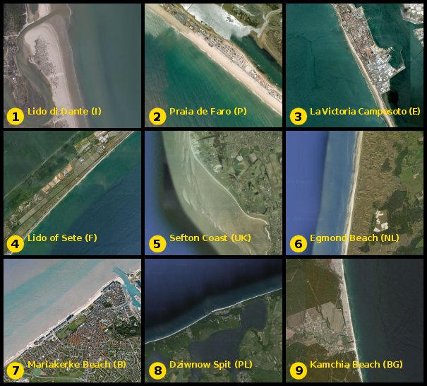
Visits since May 2011: 999